Digby Trails
  • Home
  • Digby Outdoors Map
  • Challenge badges
  • TRAILS
    • Balancing Rock >
      • Wildflowers of Balancing Rock
    • Acacia Valley >
      • Lichens of AVT
      • Wildflowers of AVT
    • Van Tassel Lake >
      • Phone of the Wind
      • Lily Lake Lollygag Trail Run
    • Gulliver's Cove
    • Fundy View Trail
    • Central Grove Trail
    • Brier Island Coastal Trail
    • Storybook Trail
    • Railbed >
      • Plan - Digby Railbed Trail
  • Point Prim Lighthouse
    • Point Prim directions
    • Further hiking at Point Prim
  • Maud Lewis
    • Maud Lewis Gravesite
  • Haines Lake
  • #digbyrocks
  • Fundy Erratics hiking club
ALL TRAILS CLOSED - May 30, 2023 and until further notice
 
In accordance with Nova Scotia Government’s announcement that all activity in wooded areas is banned, all trails within the Municipality of the District of Digby are closed until further notice.
 
Please do not enter any woods or trails – this includes the railbed. This includes hiking, fishing, cycling, riding, running and ATVing.
 
We ask that you keep safety foremost in your mind.
Effective immediately and until further notice.

Central Grove Trail

A beautiful forest trail leading to a viewing platform on the rocky Bay of Fundy coastline.
 
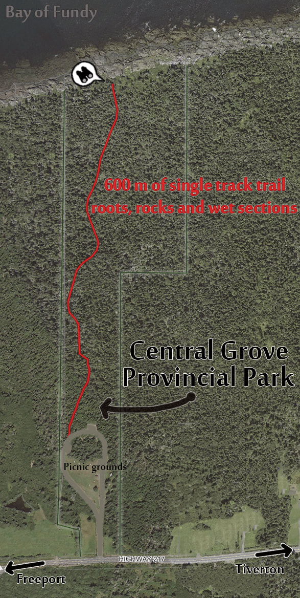
The trail starts in the north western corner of the picnic park and meanders 600m through a mixed forest with basalt outcrops and beautiful wildflowers in season. The trail provides access to the picturesque Bay of Fundy coastline for hiking, beachcombing and watching marine life.
Seals can often be seen here and whales in season.

The trail is well-groomed single track with some roots and rocks and some wet sections. It is a gentle downhill to the shore and you’ll notice the incline a bit more as you head back up. Allow 20 minutes for the stroll through this beautiful Long Island woodscape.
 
The picnic park has parking areas and picnic tables scattered through open fields and pit toilets are open in season.

From the local paper: Comparing two Long Island Trails - Balancing Rock versus Central Grove, Digby Courier, August 2011.
Picture

TRAIL MAP:

Picture
DIRECTIONS:
1731 Highway 217, Central Grove
Pretty much in the middle of Long Island, about 8 km from both Tiverton to the east and Freeport to the west.
Picture
  • Home
  • Digby Outdoors Map
  • Challenge badges
  • TRAILS
    • Balancing Rock >
      • Wildflowers of Balancing Rock
    • Acacia Valley >
      • Lichens of AVT
      • Wildflowers of AVT
    • Van Tassel Lake >
      • Phone of the Wind
      • Lily Lake Lollygag Trail Run
    • Gulliver's Cove
    • Fundy View Trail
    • Central Grove Trail
    • Brier Island Coastal Trail
    • Storybook Trail
    • Railbed >
      • Plan - Digby Railbed Trail
  • Point Prim Lighthouse
    • Point Prim directions
    • Further hiking at Point Prim
  • Maud Lewis
    • Maud Lewis Gravesite
  • Haines Lake
  • #digbyrocks
  • Fundy Erratics hiking club